But despite its modest enhancement to the Nantahala River trip, Ledbetter Creek is probably the most amazing part of the Nantahala Gorge, though to see it boaters will have to drive back up the gorge after the river trip. The trailhead is just down the road (east) of the Patton's Run pull off. You can park at the picnic area on the north side of the road (where I always park), or at the parking area by the bridge on the south side. Coming from the west, when you see the Mystic Lands development slow down, you're about there. The hike heads north, so you may as well park at the picnic area unless there's no room.
The trail begins winding through a camping area which the Forest Service seems to have marked "no camping". This is a bit maze-like, but you'll be working left (or west) to the creek, spanned by a Bartram Trail Society bridge:

After the bridge the extra side trails through the campsites consolidate into the one yellow-blazed Bartram Trail, and you're off. From here you the trail begins an uphill trek that disappointingly leads away from the creek. It's still very beautiful, but after your first experience with the lush, verdant, soothing creek, you don't want to leave. This portion of the hike gains elevation, and this is where you pay your dues for the beauty ahead. Section 7 of the Bartram Trail gains well over 3,000' in its last four miles, making it one of the most strenuous hikes around the area, and while the hike up to Bartram Falls doesn't do a third of this, it does give you a taste of that climb. This isn't extraordinarily difficult, but if you're not in good shape be prepared to take extra time and bring plenty of water. In summer heat this extended climb can challenge people. I'm in pretty good shape, and I have to pause a few times on the way up myself. This is a typical view on the uphill:


After topping out, you'll wind through a rhododendron tunnel fortified by large rock formations jutting starkly of the side of the mountain. If it's hot this is a pleasant place to cool down after the climb. In here the trail winds back down to the creek. Keep going and eventually you'll reach the first of a series of creek crossings. For me this is where I stop "hiking" and start "loafing", meaning that from here on I'm admiring/marveling more than going anywhere expeditiously. This crossing is where you'll be thankful you either a) hiked in river sandals or all condition shoes or b) brought some in your day pack to change into. There are plenty more to come, so you may as well just leave the sandals on. (I did the whole hike in Chacos yesterday and never stubbed my toe and only once or twice got debris in my shoe, so I recommend those.)
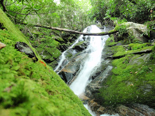
From here, you begin a gradual uphill climb along Ledbetter Creek. This gorge-in-a-gorge features lush flora (including mushrooms--there must have been 25 different types of mushrooms yesterday), lots of wildlife (we saw turkeys, salamanders, songbirds and a bunch of crazy-looking bugs) and countless picturesque cascades. Below are some of the best photos, but for a full gallery go to the Nantahala Outdoor Center Facebook page. These and many more are between the first creek crossing after the climb and the 50' Bartram Falls:


The piece d'resistance, and more or less the end of the day hike, is Bartram Falls. This is a great place to chill out, and it's worth walking up the trail just beyond the falls to see the mini-falls right above it. As always, don't go too close to this (or any of the falls). The rocks are slick, and sadly a few people die every year in North Carolina trying to get a bit too close to waterfalls, so be careful!
Here and back you're looking at a six-mile round trip. The Bartram Trail Society estimates the hike at around four hours, but give yourself a bit more time to mosey about if it's a pretty day. I recommend going in the middle of the day since you'll be in a mini-gorge with lots of shade. Things can get dark quickly, so you probably don't want to get caught in twilight without a light. Though the Bartram Trail map won't be a very helpful navigational tool for this hike (it's a map of the entire trail), it has interesting contextual information that may enhance the hike (William Bartram info, other day hikes, natural history, etc.). You can get a copy of the map, and any other necessary supplies, at Nantahala Outdoor Center's Outfitter's Store about seven miles east on US 19/74. Every hiker of this section should be grateful to the Bartram Trail Society for their diligent trail maintenance.
For more photos visit Nantahala Outdoor Center on Facebook and look for the Ledbetter Creek photo album.


No comments:
Post a Comment