"A Great Hike" by Cliff Hardin
"Hikers seeking a great hike should consider the 58 mile loop hike, utilizing the Appalachian and NC Bartram Trails, starting and ending at the Nantahala Outdoor Center.
Since this hike starts and finishes at the same place, the NOC can be used as a "base camp". This allows you to take advantage of the NOC's lodging and great restaurants the night before and the night after the hike.
You can also make arrangements to leave your vehicle in a secure parking lot. Contact NOC reservations at 1-888-905-7238 or visit their website www.noc.com for more information.
Tip: I personally like to stay in the Bartram Bunkhouse and always request one of the 2 bunk rooms, a bargain at $16 per person, per night.
5 Day, 58 mile hike:
Day One: 11.6 miles: After a good night's rest and a great breakfast at the NOC's River's End Restaurant, take the AT South from NOC. Hike to Cold Spring Shelter; spend the first night in the shelter. Water is available here, be sure to treat or filter the water. Keep in mind a lot of the 11.6 miles will be uphill, as you will be climbing to Wayah Bald the first day and part of the second day. Plan on a few rest breaks and carry enough water for the day's hike.Day Two: 10.9 miles: It is 5.9 miles from Cold Spring Shelter to Wayah Bald, with the AT and NC Bartram Trails joining just North of the summit (5,385'). Wayah Bald would be a great place for lunch, while you enjoy some awesome views, from the tower, that was built by the Civilian Conservation Corps in 1937. After you enjoy lunch and hopefully take some great pictures, take the Appalachian/Bartram Trail for 1.8 miles to Wine Springs. The BT and AT separate here. You may want to get water here before hiking on to Jarrett Bald, where you will camp for the night.
Day Three: 12.3 miles: The hike starts out with downhill for 2.5 miles to Nantahala Lake (SR 1310). After about a mile of road walking you will come to a store, on the left, where you can get a cold drink and obtain water for the rest of the day's hike. It's 9.7 miles to Piercy Creek, where you will find some nice camp sites, with water available from the creek.
Day Four: 10.8 miles: After 7.3 miles, with a lot of downhill, you will reach Nantahala River Launch (US Hwy 19/74). Be sure to go by the Bartram Historical Marker, for pictures, before hiking the 3.5 miles to the 2nd crossing of Ledbetter Creek, your camp site for the night.
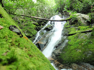
Day Five: 11.5 miles: It's 3.7 miles to Cheoah Bald (5,062'), the northern terminus of the NC Bartram Trail. From here take the AT 7.8 miles to finish the hike at NOC. Be sure to allow time for pictures at Bartram Falls and at the summit of Cheoah Bald.
After a good meal, a hot shower and good nights rest, you will be ready for the trip home, carrying with you memories of a great hike and hopefully some great pictures.
It's possible to make this a 3 day, 40 mile hike by getting a shuttle from NOC to Wayah Bald, thus eliminating the climb from NOC to Wayah Bald on the AT.
Tip: I have been successful in obtaining an early morning shuttle for my Bartram thru-hikes from NOC employees prior to their going to work. You can still leave your vehicle in a secure parking lot and will be hiking back to the NOC.
3 day, 40 mile hike:
Day One: 13.5 miles: Wayah Bald to Nantahala Lake 7.5 miles, then 6 miles to Appletree Campgrounds. There are nice camp sites, just north of Appletree.
Day Two: 15 miles from Appletree Campgrounds to 2nd crossing of Ledbetter Creek.
Day Three: 11.5 miles: Same as day 5 of the 58 miles hike.
I highly recommend that the Bartram Trail Maps be obtained and used in planning any hike on the Bartram. The maps are available on the NC Bartram Trail Society website online store. http://ncbartramtrail.org (or available at Ranger Stations). The cost is only $15.00 for the entire set of seven maps, and you can use maps 1-4 to plan your hikes of the rest of the NC Bartram Trail. You may also want to consider becoming a member of the NC Bartram Trail Society.
As you hike the NC Bartram Trail, keep in mind that you will be taking a trip back in early US history. The trail follows, as near as possible, the travels of William Bartram through the beautiful mountains of Western North Carolina in the mid 1770's.
Enjoy your hike,
-Cliff Hardin, NCBTS Board Member"
Thanks for the article Cliff! Here is a slideshow of images that Cliff put together of his personal trip down the trail:
Enjoy!
-John Puckett